History of
Ground Proximity Warning
Trans World Airlines
Flight 514, registration N54328, was a
Boeing 727-231
en route from
Indianapolis and
Columbus, Ohio,
to
Washington Dulles International
that crashed into Mount Weather, Virginia, on December 1, 1974. All
85 passengers and 7 crew members were killed.
The flight was
originally destined for
Washington National Airport.
However, the plane diverted to Dulles when high
crosswinds,
east at 28 knots and gusting to 49 knots, prevented safe operations
on the main north-south
runway at
Washington National. The flight was being
vectored for
a non-precision instrument approach to runway 12 at Dulles.
Air traffic controllers
cleared the flight down to 7,000 feet before clearing them for the
approach while not on a published segment.
The jetliner began a descent
to 1,800 feet shown on the first checkpoint for the published
approach. The voice recorder indicated there was some confusion in
the cockpit over whether they were still under a radar controlled
approach segment which would allow them to descend safely. After
reaching 1,800 feet there were some 100-to-200-foot altitude
deviations which the flight crew discussed as encountering heavy
downdrafts and reduced visibility in snow. The plane impacted the
west slope of Mount Weather at 1,670 feet at approximately 230 knots
(260 mph). The wreckage was contained within an area about 900 feet
long and 200 feet wide. The evidence of first impact was trees whose
tops were cut off about 70 feet feet above the ground. The elevation
at the base of the trees was 1,650 feet. The wreckage path was
oriented along a line 118 degrees magnetic. Calculations indicated
that the left wing went down about 6 degrees as the aircraft passed
through the trees and the aircraft was descending at an angle of
about 1 degree. After about 500 feet of travel through the trees,
the aircraft struck a rock outcropping at an elevation of about
1,675 feet. Numerous heavy components of the aircraft were thrown
forward of the outcropping. Numerous intense post-impact fires were
located, and extinguished. The mountain's summit is at 1,754 feet.
The accident investigation
board was split in its decision as to whether the flight crew or Air
Traffic Control
were
responsible.
The majority
absolved the controllers as the plane was not on a published
approach segment. The dissenting opinion was that the flight had
been radar vectored. Terminology between pilots and controllers
differed without either group being aware of the discrepancy. It was
common practice at the time for controllers to release a flight to
its own navigation with "Cleared for the Approach," and flight crews
commonly believed that was also authorization to descend to the
altitude at which the final segment of the approach began. No clear
indication had been given by controllers to Flight 514 that they
were no longer on a radar vector segment and therefore responsible
for their own navigation. Procedures were clarified after this
accident. Controllers now state, "Maintain (specified altitude)
until established on a portion of the approach," and pilots now
understand that previously assigned altitudes prevail until an
altitude change is authorized on the published approach segment the
aircraft is currently flying.
In addition, the published
approach chart was redesigned to remove the erroneous previous
information.
Enter GPWS
At the time of the accident
there were two (2) companies that had, on the shelf, GPWS (Ground
Proximity Warning System) that used the radio altimeter as the
primary source of input information. In addition, AMSADD (Automatic
Minimum Safe Altitude) was conceived and presented to the aviation
community.
The two companies were
Sundstrand Corporation and Allied Signal. Both companies eventually
were merged into Hamilton Standard and Honeywell Corporation.
Each GPWS system was somewhat similar, with one costing $5000 and
the other $10,000. One gave a warning sound with a "Whoop Whoop,
Pull Up" and the other a "Whoop Whoop, Terrain" aural warning.

�ntsb
No one single person invented
GPWS regardless of what Aviation Week, Flying Magazine, and
Wikipedia reported (fake news). The idea was conceived by two different
companies and engineers simultaneously. Both companies lobbied
Washington for the equipment and GPWS was mandated for the airlines.Since that time CFIT
(Controlled Flight Into Terrain) has not been solved and there are
now over one hundred 'near misses' since GPWS, where the aircraft has
just missed impacting the terrain because the GPWS warning allowed
the aircraft to descend below the Minimum Safe Altitude.
|
|
Since GPWS
does not protect the aircraft on final approach, except for
configuration errors, there have been
numerous CIFT accidents while on final approach. A US
accident was Asiana Airlines approach to San Francisco. The onboard
GPWS gave no warning that the aircraft was too low with the ILS
glide slope out of commission. AMSADD would have immediately alerted
the crew they were too low. AMSADD monitors all final approaches,
regardless of either non precision or precision approaches.
On August 3, 2017 an Air
Canada jet lined up with the taxiway and came within 59 feet of
hitting two commercial jets waiting for takeoff. Once again GPWS was
of no use and gave no warning to the Air Canada crew. Since more
than one half of all CFIT accidents occur on final approach, except
for configuration errors, GPWS is
useless. See
https://goo.gl/jz4Uso
. AMSADD
would have immediately alerted the crew they were not lined up with
the runway.
NASA is now testing a new
type of GPWS that has similar displays to the present system in use. See YouTube video:
https://www.youtube.com/watch?v=Erz4cdRNWZI
This adds credence that even NASA thinks the present GPWS is
inadequate! However, once again using the NASA system, the MSA is
ignored. As a result, six fighter jets almost impacted the terrain
in 2016 by descending below the Minimum Safe Altitude.
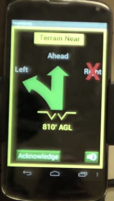
Notice that this warning
indicates the aircraft is only 810 feet from terrain impact.
AMSADD is simple
in concept and uncomplicated to understand. AMSADD is
"intelligent" in that its programming logic
is to "think and act" as a
pilot would in an actual flying environment. This is
the "Extra" crew member that watches over
you as you fly and gently reminds you when no one is
"watching the store."
AMSADD, guides you
through complicated missed approach and instrument
departures in addition to providing the ultimate in
terrain awareness.
Affordable and
transportable. Smart Phone downloadable is FREE, not $200,000.
|